Dátový katalóg geoPresovRegion
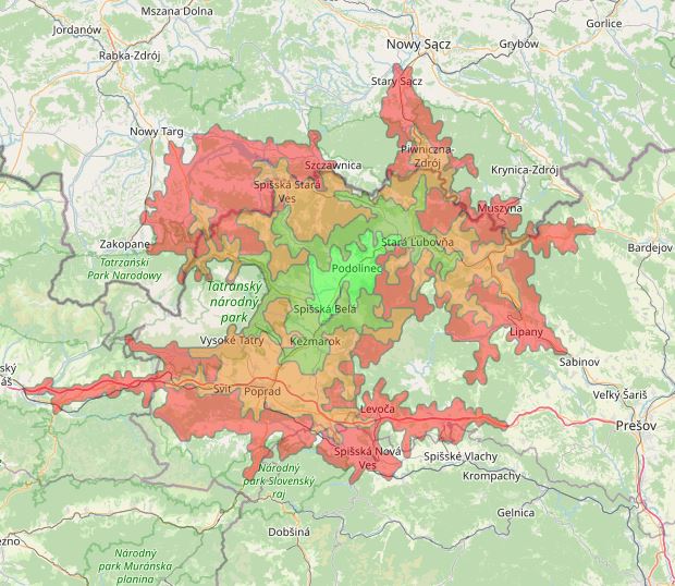
Časová dostupnosť mesta Podolínec (15 min. interval)
Časová dostupnosť mesta Podolínec do jednej hodiny v 15-minútových intervaloch. Vrstva je tvorená metódou isochrónnych línií, ktoré spájajú miesta s rovnakou časovou dostupnosťou na základe výpočtov služby HERE REST API © 2020 spoločnosti Here https://developer.here.com/
---English---
Time availability of the city Podolínec within one hour at 15-minute intervals. The layer consists of a method of isochronic lines linking positions with equal time availability based on service computation HERE REST API © 2020 Here comp. https://developer.here.com/
Simple
- Date (Publication)
- 2020-07-10
- Citation identifier
- c4be841a-d15b-405a-a12a-587b2f2b331d
- Status
- Completed
- Point of contact
-
Organisation name Individual name Electronic mail address Role Prešovská univerzita v Prešove
PU, Katedra geografie a aplikovanej geoinformatiky
Processor
- Maintenance and update frequency
- Irregular
-
Keywords
-
-
dostupnosť
-
isochrone
-
- Use constraints
- Other restrictions
- Other constraints
-
Creative Commons Attribution 4.0 International (CC BY 4.0)
- Access constraints
- Other restrictions
- Other constraints
- Bez obmedzenia prístupu
- Spatial representation type
- Vector
- Denominator
- 5000
- Language
- Slovak [SK]
- Character set
- UTF8
- Topic category
-
- Transportation
))
- Reference system identifier
- EPSG: 3857
- Distribution format
-
Name Version gml+xml 3.2
- OnLine resource
-
Protocol Linkage Name OGC:WMS-1.3.0-http-get-map
https://geopresovregion.sk/geoserver/wms/ geo-psk:dostup_Podolinec
WWW:DOWNLOAD-1.0-http--download
https://geopresovregion.sk/geoserver/wfs?SERVICE=WFS&REQUEST=GetFeature&VERSION=1.0.0&TYPENAME=geo-psk:dostup_Podolinec&OUTPUTFORMAT=SHAPE-ZIP&srsName=EPSG:3857 WWW:DOWNLOAD-1.0-http--download
https://geopresovregion.sk/geoserver/wfs?SERVICE=WFS&REQUEST=GetFeature&VERSION=1.0.0&TYPENAME=geo-psk:dostup_Podolinec&OUTPUTFORMAT=SHAPE-ZIP&srsName=EPSG:5514 OGC:WFS
https://geopresovregion.sk/geoserver/wfs geo-psk:dostup_Podolinec
- Hierarchy level
- Dataset
Conformance result
- Alternate title
-
Commission Regulation (EU) No 1089/2010 of 23 November 2010 implementing
Directive 2007/2/EC of the European Parliament and of the Council as regards interoperability of
spatial data sets and services
- Date (Publication)
- 2010-12-08
- Explanation
-
Viď Nariadenie Komisie (EÚ) č. 1089/2010
- Pass
- No
- Statement
-
Povinné - vyplniť / Mandatory (INSPIRE)
Metadata
- File identifier
- c4be841a-d15b-405a-a12a-587b2f2b331d XML
- Metadata language
- Slovak [SK]
- Character set
- UTF8
- Hierarchy level
- Dataset
- Date stamp
- 2021-09-01T08:24:47
- Metadata standard name
-
ISO 19115:2003/19139
- Metadata standard version
-
1.0
- Metadata author
-
Organisation name Individual name Electronic mail address Role Prešovský samosprávny kraj - kontakt
Inštitút rozvoja PSK - GIS tím
Point of contact
Overviews
Spatial extent
Provided by