Dátový katalóg geoPresovRegion
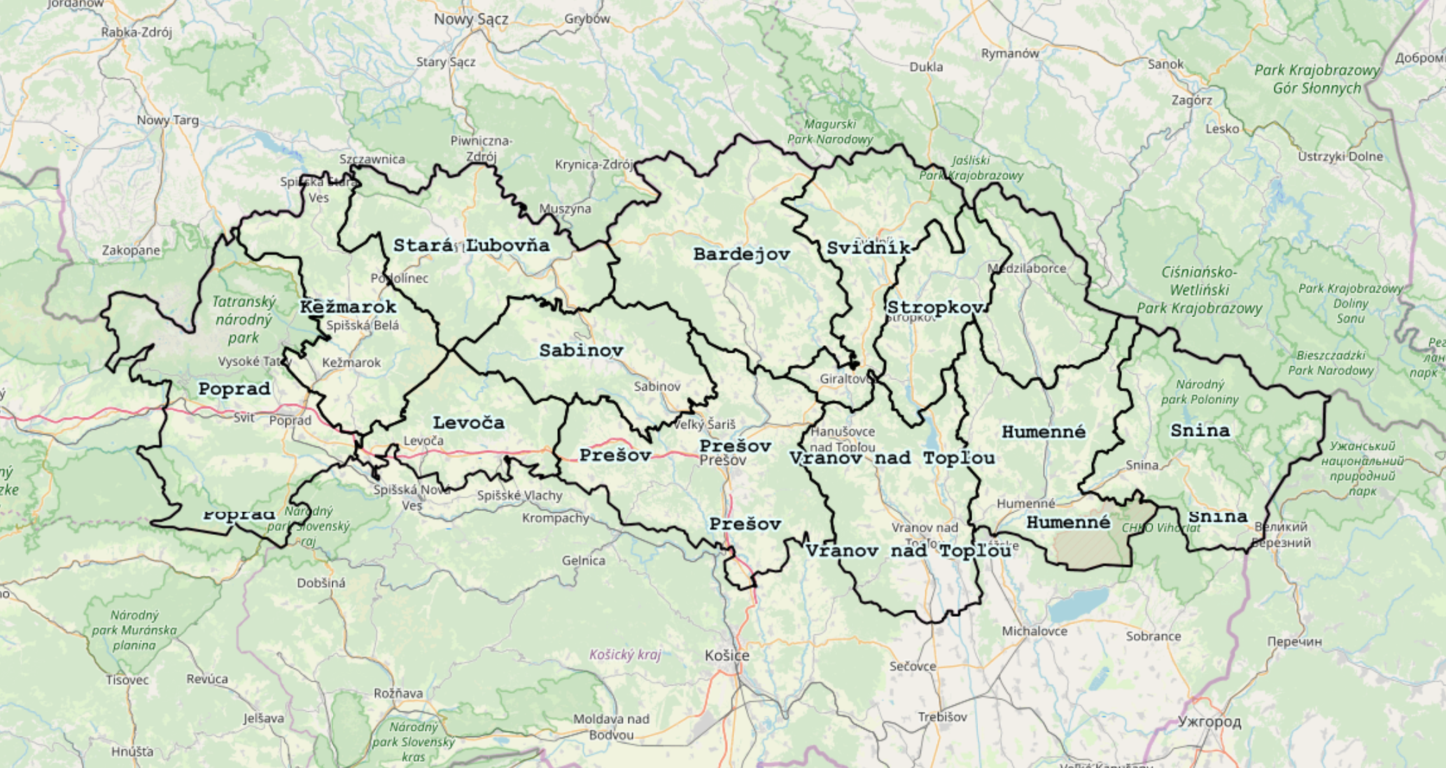
Administratívne hranice okresov Prešovského samosprávneho kraja
Administratívne hranice okresov Prešovského samosprávneho kraja spracované spojením datasetov "Hranice územného a správneho usporiadania SR v základnej úrovni - Základná báza GIS (ZB GIS)" a "Registra priestorových jednotiek ŠÚ SR (REGPJ)", pričom zachované boli názvy stĺpcov IDN a NM spolu (ZB GIS) s lokálnymi štatistickými územnými jednotkami 2 (REGPJ)
Zdroj:
https://www.geoportal.sk/sk/udaje/udaje-zbgis/udaje-zbgis/uzemne-spravne-usporiadanie/
https://slovak.statistics.sk/wps/portal/ext/Databases/REGPJ/
Simple
- Date (Publication)
- Citation identifier
- b2f80775-0930-4abb-8041-bc8310492a45
- Status
- Completed
- Point of contact
-
Organisation name Individual name Electronic mail address Role Úrad geodézie, kartografie a katastra SR
Úrad geodézie, kartografie a katastra SR
Address of the electronic mailbox of the responsible organization or individual
Author
- Maintenance and update frequency
- As needed
-
Keywords
-
-
administratívne hranice
-
- Use constraints
- Other restrictions
- Other constraints
-
Creative Commons Attribution 4.0 International (CC BY 4.0)
- Access constraints
- Other restrictions
- Other constraints
- Bez obmedzenia prístupu
- Spatial representation type
- Vector
- Denominator
- 5000
- Language
- Slovak [SK]
- Character set
- UTF8
- Topic category
-
- Boundaries
))
- Reference system identifier
- EPSG: 3857
- Distribution format
-
Name Version gml+xml 3.2
- OnLine resource
-
Protocol Linkage Name OGC:WMS-1.1.1-http-get-map
https://geopresovregion.sk/geoserver/wms/ geo-psk:admunit_districts
OGC:WFS
https://geopresovregion.sk/geoserver/wfs geo-psk:admunit_districts
- Hierarchy level
- Dataset
Conformance result
- Alternate title
-
Commission Regulation (EU) No 1089/2010 of 23 November 2010 implementing
Directive 2007/2/EC of the European Parliament and of the Council as regards interoperability of
spatial data sets and services
- Date (Publication)
- 2010-12-08
- Explanation
-
Viď Nariadenie Komisie (EÚ) č. 1089/2010
- Pass
- No
- Statement
-
Povinné - vyplniť / Mandatory (INSPIRE)
Metadata
- File identifier
- b2f80775-0930-4abb-8041-bc8310492a45 XML
- Metadata language
- Slovak [SK]
- Character set
- UTF8
- Hierarchy level
- Dataset
- Date stamp
- 2021-09-01T08:26:17
- Metadata standard name
-
ISO 19115:2003/19139
- Metadata standard version
-
1.0
- Metadata author
-
Organisation name Individual name Electronic mail address Role Prešovský samosprávny kraj - kontakt
Inštitút rozvoja PSK - GIS tím
Point of contact
Overviews
Spatial extent
Provided by