Dátový katalóg geoPresovRegion
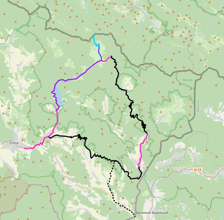
Poloniny trail
Poloniny Trail
Prešovský samosprávny kraj (PSK) sa v rámci výstupov Akčného plánu iniciatívy Európskej komisie za podpory Svetovej Banky „Catching-up Regions II“ zaviazal účinne podporovať rozvoj endogénneho potenciálu cestovného ruchu v oblasti Národného parku Poloniny. Na tento účel bol navrhnutý expertmi Svetovej banky tzv. „Poloniny trail“ – viacúčelová turistická trasa, ktorá sa bude napájať na sieť existujúcich cykloturistických trás vedúcich po miestnych komunikáciách. Vytvorenie „Poloninskej turistickej trasy“ sa zakladá na zrekonštruovaní a vybudovaní mäkkej a tvrdej infraštruktúry ako východiskových podmienok zlepšenia dostupnosti medzi obcami a skvalitnenia súčasnej turistickej a cyklistickej infraštruktúry.
Simple
- Date (Publication)
- 2020-12-15
- Citation identifier
- 8a9b5fa3-e686-49dd-baa0-1d48df55ad17
- Status
- Under development
- Point of contact
-
Organisation name Individual name Electronic mail address Role Prešovský samosprávny kraj - autor/vlastník údajov
Inštitút rozvoja PSK
Author
- Maintenance and update frequency
- Irregular
-
Keywords
-
-
cyklotrasa
-
RPI
-
poloniny
-
-
GEMET - INSPIRE themes, version 1.0
-
-
Využitie územia
-
- Use constraints
- Other restrictions
- Other constraints
-
Creative Commons Attribution 4.0 International (CC BY 4.0)
- Access constraints
- Other restrictions
- Other constraints
- Bez obmedzenia prístupu
- Spatial representation type
- Vector
- Denominator
- 25000
- Language
- Slovak [SK]
- Character set
- UTF8
- Topic category
-
- Planning cadastre
))
- Supplemental Information
-
You can customize the template to suit your needs.
You can add and remove fields and fill out default information (e.g. contact details).
- Reference system identifier
- EPSG: 3857
- Distribution format
-
Name Version gml+xml 3.2
- OnLine resource
-
Protocol Linkage Name OGC:WMS-1.3.0-http-get-map
https://geopresovregion.sk/geoserver/wms/ geo-psk:pt_last
OGC:WFS
https://geopresovregion.sk/geoserver/wfs geo-psk:pt_last
WWW:DOWNLOAD-1.0-http--download
https://geopresovregion.sk/geoserver/wfs?request=GetFeature&service=wfs&version=1.0.0&typename=geo-psk:pt_last&outputformat=SHAPE-ZIP&srsName=EPSG:5514
- Hierarchy level
- Dataset
Conformance result
- Alternate title
-
Commission Regulation (EU) No 1089/2010 of 23 November 2010 implementing Directive 2007/2/EC of the European Parliament and of the Council as regards interoperability of spatial data sets and services
- Date (Publication)
- 2010-12-08
- Explanation
-
Viď Nariadenie Komisie (EÚ) č. 1089/2010
- Pass
- No
- Statement
-
Povinné - vyplniť / Mandatory (INSPIRE)
Metadata
- File identifier
- 8a9b5fa3-e686-49dd-baa0-1d48df55ad17 XML
- Metadata language
- Slovak [SK]
- Character set
- UTF8
- Hierarchy level
- Dataset
- Date stamp
- 2023-11-06T09:14:54Z
- Metadata standard name
-
ISO 19115:2003/19139
- Metadata standard version
-
1.0
- Metadata author
-
Organisation name Individual name Electronic mail address Role Prešovský samosprávny kraj - kontakt
Inštitút rozvoja PSK - GIS tím
Point of contact
Overviews
Spatial extent
Provided by