Dátový katalóg geoPresovRegion
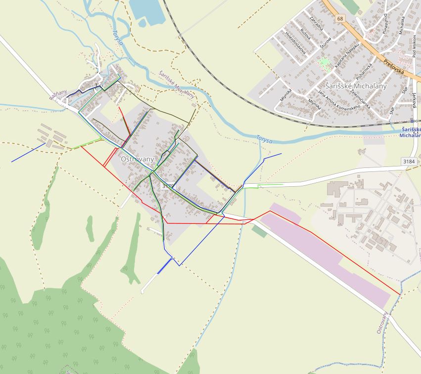
Technická infraštruktúra v obci Ostrovany
Datasety technickej infraštruktúry boli spracované v spolupráci s Európskou komisiou, Svetovou Bankou a expertmi a študentmi Fakulty prírodných a humanitných vied, Prešovskej univerzity v Prešove (PU) v pilotných šiestich obciach v rámci iniciatívy „Catching-up regions“.
Základnú bázu údajov tvorili dáta z územných plánov obcí, ktoré boli aktualizované v spolupráci so starostami jednotlivých obcí. Zozbierané údaje boli digitalizované, spracované do mapových výstupov a implementované do Plánov hospodárskeho a sociálneho rozvoja daných obcí.
Údaje sú aktuálne k dátumu 9/2020.
V atribúte „druh“ sú definované jednotlivé typy technickej infraštruktúry.
Simple
- Date (Publication)
- 2020-12-03
- Citation identifier
- 9e068dcc-8e06-464d-80dd-82d6295e6361
- Status
- Completed
- Point of contact
-
Organisation name Individual name Electronic mail address Role Prešovský samosprávny kraj - autor/vlastník údajov
Inštitút rozvoja PSK
Author
- Maintenance and update frequency
- As needed
-
Keywords
-
-
regionálny rozvoj
-
infraštruktúra
-
-
GEMET - INSPIRE themes, version 1.0
-
-
Verejné a štátne služby
-
- Use constraints
- Other restrictions
- Other constraints
-
Creative Commons Attribution 4.0 International (CC BY 4.0)
- Access constraints
- Other restrictions
- Other constraints
- Bez obmedzenia prístupu
- Spatial representation type
- Vector
- Denominator
- 5000
- Language
- Slovak [SK]
- Character set
- UTF8
- Topic category
-
- Utilities communication
))
- Supplemental Information
-
You can customize the template to suit your needs.
You can add
and remove fields and fill out default information (e.g. contact
details).
Fields you can not change in the default view may be accessible in the
more
comprehensive (and more complex) advanced view. You can even use the
XML editor
to create custom structures, but they have to be validated by the
system, so
know what you do :-)
- Reference system identifier
- EPSG:3857
- Distribution format
-
Name Version gml+xml 3.2
- OnLine resource
-
Protocol Linkage Name OGC:WMS-1.3.0-http-get-map
https://geopresovregion.sk/geoserver/wms geo-psk:rsm_ostrovany_infra
OGC:WFS
https://geopresovregion.sk/geoserver/wfs rsm_ostrovany_infra
- Hierarchy level
- Dataset
Conformance result
- Alternate title
-
Commission Regulation (EU) No 1089/2010 of 23 November 2010 implementing Directive 2007/2/EC of the European Parliament and of the Council as regards interoperability of spatial data sets and services
- Date (Publication)
- 2010-12-08
- Explanation
-
Viď Nariadenie Komisie (EÚ) č. 1089/2010
- Pass
- No
- Statement
-
Základnú bázu údajov tvoria dáta z územného plánu obce, ktoré boli aktualizované a vektorizované v spolupráci so zástupcami miestnej samosprávy.
Metadata
- File identifier
- 78c9351c-72f7-426f-9f92-d47ece880f56 XML
- Metadata language
- Slovak [SK]
- Character set
- UTF8
- Hierarchy level
- Dataset
- Date stamp
- 2021-09-01T08:27:23
- Metadata standard name
-
ISO 19115:2003/19139
- Metadata standard version
-
1.0
- Metadata author
-
Organisation name Individual name Electronic mail address Role Prešovský samosprávny kraj - kontakt
Inštitút rozvoja PSK - GIS tím
Point of contact
Overviews
Spatial extent
Provided by